Have your say - where should we go next?

We’re on the horns of a terrible (Ok, actually a pretty wonderful) dilemma.
In January we set sail from Phuket for Sri Lanka. We’ve just decided that we’ll then sail onto Cochin in India for a couple of weeks.
But after that, we don’t know whether to turn left or right. And that’s where you come in.
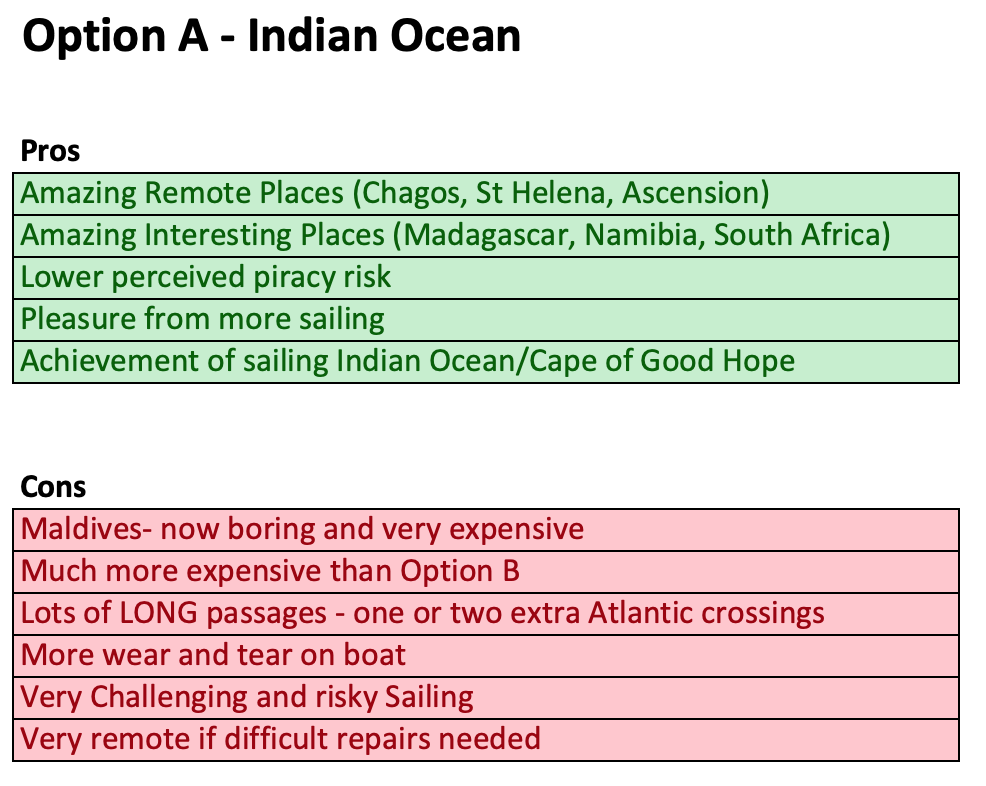
Turn left, and we’ll head south through the Indian Ocean. Our stops will be The Maldives, Chagos, Rodrigues, Mauritius, Reunion, Madagascar and South Africa. It will take us until late October to get to South Africa, after which we’ll be aiming to get to the UK for May to work for a year.
And that next leg is a LONG haul!
From Cape Town we’ll head up the Namibian Coast, then sail to St Helena and then Ascension Island, both in the middle of the South Atlantic. After brief stops in each of those lonely outposts, we’d have to undertake the longest passage of our circumnavigation, to the Azores, in the middle of the North Atlantic (some 40 days non-stop), before another two to three week passage to get us to the UK.
So that’s Option A. And it’s a good one.
Here’s the rest of our trip if we follow Option A - click to enlarge
It involves some of the most remote and interesting destinations on our planned voyage (Chagos, St Helena and Ascension Island), as well as some of the most interesting (Madagascar and Namibia), most beautiful (The Maldives), and most land-based attractions (South Africa).
But there are a few downsides.
For starters, the cost/benefit analysis for stopping at The Maldives has just significantly changed for the worse. It has always been one of the most expensive places to stop for sailors – typically it costs around $1,000 - $2,000 just in government fees (the exact amount depends on how long you stay).
But for reasons best known to themselves, the Maldivian government has decided to try and actively discourage sailors, and as of this year, now insists that cruisers can only stop at 8 different locations.
Of course, these are all built up towns with a tourism industry, so if sailors wish to visit any of the many dozens of remote beautiful atolls – the very reason for going in the first place – they need to stop at a town, leave their boat there (which is dangerous as the anchorages are not protected from wind) and then pay a tourist boat to take you along with dozens of others, to the pretty places.
You also have to pay to carry a government tracker so they can monitor you to avoid you ducking off on your own.
It’s the very antithesis of why we’re doing this, of why we endure the hardships and costs of sailing around the world ourselves.
Oh, and to compound things, one of the best reasons for visiting the Maldives – the amazing snorkelling and diving - is also now questionable, due to extensive coral bleaching in the area.
So why not just scoot on by? Well, unfortunately, it’s pretty hard to avoid stopping there, as it’s just about the only place where you can fill up with fuel for the next stage of the journey (and those thousand dollar costs apply whether you’re stopping for a day or a month). Plus you also need to kill some time waiting for the season to change - you can’t leave earlier either due to seasonal weather issues.
So Option A involves sucking up an expensive and not particularly enjoyable month or two in the Maldives being tracked by the government while you sit and wait for the weather to change.
Then there’s also the extra mileage we’d be travelling.
Compared with Option B (more on that later), we’ll be travelling an extra 10,000 miles – this involves a significant amount of additional cost due to fuel and wear and tear on the boat, plus an entire extra year.
We had originally budgeted for both of these, but since we lost a year in our plan due to the well documented problems with our roof, Option B allows us to get back on track, as well as offering some undoubted upsides of it’s own.
And finally, there’s the significant challenge that sailing through the Indian Ocean (especially the southern half) entails. I wrote about those in an earlier blog, but in short, it’s bloody remote, with some of the toughest winds, tides and waves we’ll encounter anywhere in the world.
So what is Option B?
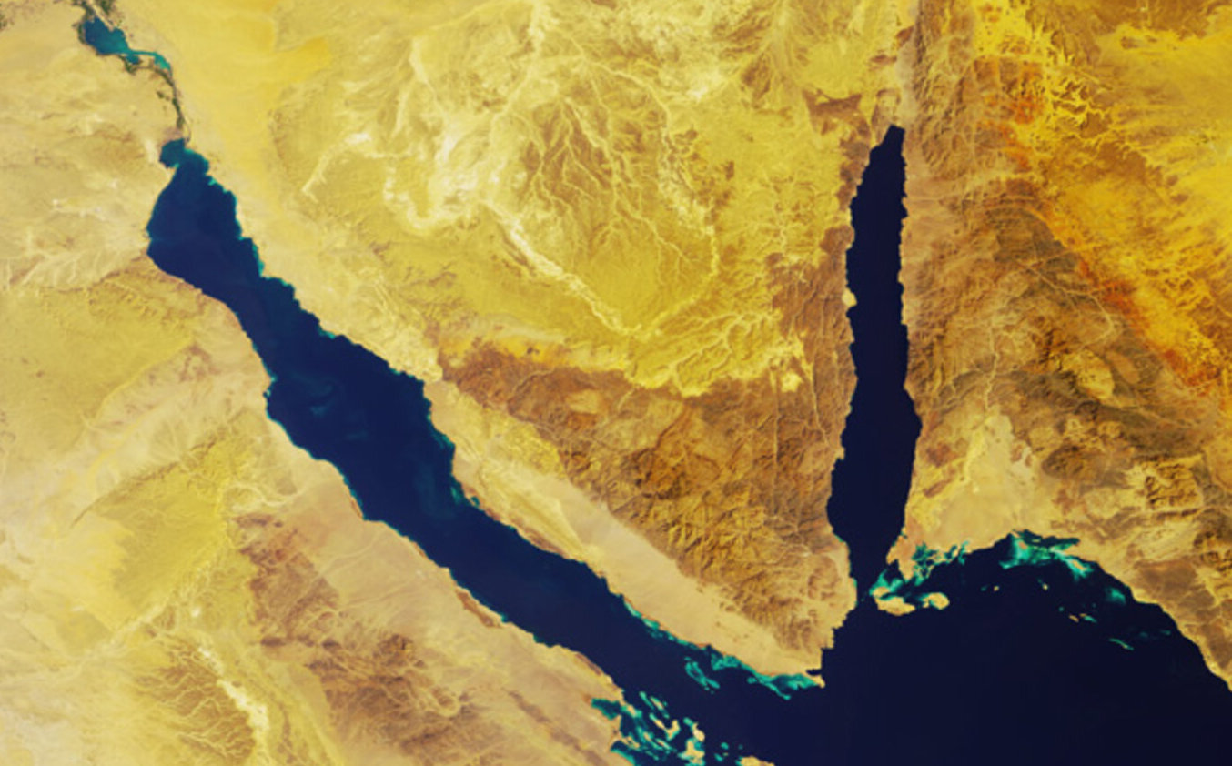
From Cochin, India in February, we’d turn right, and head to Oman, Yemen, Djibouti, Eritrea, Sudan and Egypt, before transiting the Suez Canal and popping out in the Mediterranean in April.
This would enable us to see some of the more interesting places in the Middle East (unique and different from anything else in our circumnavigation, albeit we’d be rushing through fairly quickly), before then giving us a much longer, more realistic and enjoyable time in Europe than would happen under Option A.
Here’s the rest of our trip if we select Option B - click to enlarge
We’d spend spring and summer of 2020 in the Eastern Med (Turkey, Greece, Croatia and maybe Venice), before making a quick passage to the UK for August/September and working for 6-8 months through winter. Then in the spring of 2021, we’d sail Scotland and Scandinavia, before spending another 6 months working back in the UK. Finally, in the Spring of 2022, we’d head back to the Med, sail the western half (Portugal, Spain, France, Corsica, Sardinia), before heading to Madeira and the Canaries in September/October and then across to the Caribbean in November.
Although Option A does include spending time in the Med after working in the UK, it would be a lot more rushed, and would give us only 2 months for Scotland/Scandinavia, rather than the 6 months under Option B. And since sailing in Scotland will be one of the highlights for me in this entire trip, for obvious reasons, it seems a shame to rush it when there’s an option that gives us much more time there.
Other benefits of Option B include an extra year in the UK (albeit split up over a couple of years with cruising in between), which allows more time with family and friends.
Finally, we’ve always factored in spending 12 months working in the UK as an essential part of budget management, and also of keeping our skills relevant in the workplace. Under Option B, we’d be doing this a year earlier than Option A, which should theoretically make it easier for us to find work (it will only have been two years since we stopped working, rather than three).
But of course, there are some downsides involved in Option B.
Let’s get the obvious one out of the way – pirate alley!
When we first started thinking about this trip in 2010, the Red Sea and the Suez Canal was part of the original plan. It made a lot of sense given how much shorter it is than going around the Cape of Good Hope (South Africa), and there was something romantic to me about sailing through the Suez Canal.
My initial investigations, however, raised major alarm bells. There are a few global hotspots for piracy, and the Horn of Africa, off the coast of Somalia, had recently become the most notorious. In fact, in 2010/2011 there were numerous cases of yachts being boarded by armed men, and at best, valuables being stolen, and at worst, the sailors kidnapped for ransom or simply murdered where they were.
It rapidly become a no go area for yachties, and the southern route (what I’m calling Option A above) became the only one considered by sensible cruisers. An intrepid few did continue to make the journey through the Red Sea, and incidents continued to occur, albeit at a slower rate than the peak in 2010/2011.
The British Navy, along with those of several other countries, started patrolling the area, and unofficially offering protection for those yachties that did make the journey. But while there was some reassurance to be had from that, it was far from a guarantee, given the huge area of ocean to be covered.
Yachties also started grouping together to travel in convoy, on the basis that this should offer strength in numbers, and that practice continues to this day. These convoys typically travel without lights or AIS switched on, and usually maintaining radio silence also.
By the time we set off from Australia in 2018, there had been only one reported incident in the previous two years, although it was hard to know whether what was because so few yachts were actually attempting the journey.
When we arrived in Thailand last December, however, we were astonished to discover that at least half of the yachties we spoke to were planning to go through the Red Sea in January 2019. We decided to stick with our original plan, but we were heartened to hear that the problem seemed to have dissipated, and we have followed along with interest since then.
It’s hard to get exact numbers, but we know of at least 40 yachts that went through the Red Sea last year, with 0 incidents. That’s more vessels than we know of that went the Southern route, albeit we don’t have a complete picture. But it does some like it’s around 50:50 at the moment.
You might argue why take any risk at all? But there’s always some risk of piracy everywhere, and there are certainly places elsewhere with a much more fearsome reputation right at the moment than the Red Sea.
If we wanted to avoid risk altogether, we’d still be sitting at our desks in Sydney!
Currently there’s even a sense that the Somali pirates have now focused their attention south of the Red Sea, towards the Seychelles and further south, given the extra patrols conducted by the various navies, along with the greater care being taken by yachties. And although our Option A route would keep us clear of these new “risky” areas, it would definitely still involve the Mozambique Channel which has had a few reports of attacks in recent times.
So perhaps the Red Sea might even be safer than the Indian Ocean. It’s really hard to know for sure.
Since we decided last year to “stay the course” (pun intended), our circumstances changed due to the lost year with the roof, so now, along with the added benefit of a year’s worth of data from yachts we actually know, the risk/benefit equation for the Red Sea has changed significantly.
But the risk of piracy is not the only downside for Option B. While the sailing conditions in the southern Indian Ocean is a major challenge, the Red Sea route is no picnic either. At least with the southern route, the wind and waves are mostly behind you. With the Red Sea, the wind is on the nose pretty much the entire time, which means hundreds of miles of punishing beating or motoring to windward. It’s a passage to be endured, rather than enjoyed.
And even though the risk of piracy seems to have abated, there are still many areas along the journey enduring political upheaval, which carries with it it’s own attendant risks.
Finally, there’s the opportunity cost of the Red Sea route – namely, missing out on all those wonderful places we’d see with Option A. The same doesn’t apply in reverse - with the exception of the whistle stop tour through the countries of the Red Sea, all the other places we’d be seeing in Option B we’ll still see under Option A, albeit for much less time.
Confused? Us too! So here’s a quick chart summarising the pros and cons of each route.

So, now it’s your turn. Can you help us decide?
We’re genuinely 50:50 at the moment, so would love to hear your feedback.
What would YOU do? And what do you think WE should do (if that’s different)?
Are there any factors we haven’t thought about yet?
Leave a comment here or on Facebook – we’re not saying that we’ll go with the majority, but we are hoping that hearing your thoughts will influence our thinking.
Have at it!